
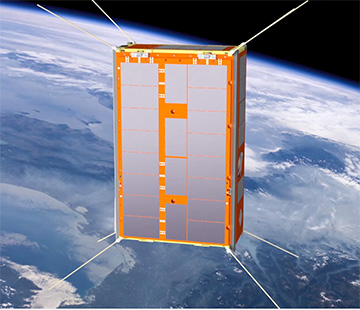
An artist’s rendering of the Kanyini CubeSat, slated for launch later in 2024. [Image: SmartSatCRC]
“Where there’s smoke, there’s fire” is a time-worn adage about how small signs and rumors can point to dangerous hidden truths. That old saying also encapsulates a novel approach that will be used to help prevent potentially devastating wildfires, by tracking their telltale smoke from a CubeSat perched in low Earth orbit.
The orbital system will combine a compact hyperspectral-imaging instrument on the South Australia–developed Kanyini 6U CubeSat, slated for launch later this year, with a nifty onboard AI system for preprocessing and interpreting the data. A team led by scientists from the University of South Australia recently published results of a prelaunch dry run of the system to show what it’s capable of (IEEE J. Sel. Top. Appl. Earth Obs. Remote Sens., doi: 10.1109/JSTARS.2024.3394574).
Addressing an escalating threat
The wildfire-sniffing system trialed by the South Australian team will rely on the HyperScout-2 (HS2) hyperspectral imaging sensor to be carried aloft by Kanyini. The compact imager, developed by the Netherlands-based engineering company Cosine specifically for use on shoebox-sized CubeSats, is capable of hyperspectral imaging in the visible and near-infrared across a swath as wide as 300 km. The camera also supports imaging in three thermal-infrared bands to enable remote temperature sensing.
The wildfire-sniffing system trialed by the South Australian team will rely on the HyperScout-2 hyperspectral imaging sensor to be carried aloft by the Kanyini CubeSat, launching later this year.
The Kanyini mission’s raison d’être is to use HS2’s capabilities to remotely collect data on Australian bushfires—an emerging and escalating threat in an era of climate change—as well as on inland and coastal water quality. With respect to bushfires, the authors of the new study note that “smoke is usually the first thing you can see from space before the fire gets hot and big enough for sensors to detect fire heat.” That makes early detection of smoke a crucial advance-warning tool that can help stop nascent bushfires in their tracks.
The downlink dilemma
Hyperspectral imaging, which captures and stores full spectral information from each imaging pixel, offers a potentially powerful tool for mapping and identifying patterns smoke across large areas on the ground from an orbital observing post. One problem, though, is that hyperspectral imaging generates prodigious amounts of data, stored in vast 3D “data cubes” that encode the complete spectrum at each x–y coordinate.
Beaming those data—only a fraction of which will actually be useful in detecting wildfire smoke—to ground-based stations for analysis would consume precious time. That’s especially true given the recent proliferation of microsatellites (like Kanyini) in low Earth orbit. This spacecraft glut has substantially increased overall satellite-to-ground bandwidth usage, making such data downlinks ever slower and more challenging.
Indeed, given these bandwidth constraints, it’s even possible that an orbiting satellite that had detected hints of emerging bushfires might not be able to send the data to a ground station for processing and analysis until its next orbital pass, as much as six hours later. By then, the bushfire may be well established—and much harder to control.
Fortunately, Kanyini’s HS2 instrument includes AI hardware accelerators that enable processing of the hyperspectral data on the satellite itself. This could dramatically reduce the downlink size and, in the context of smoke detection, potentially speed up the data’s transmission to early-warning systems on the ground. And that, in turn, might save crucial time in deploying teams to get the upper hand on emerging bushfires.
Training data and hardware hacking
The team behind the recently published prelaunch study—including scientists from the University of South Australia, Swinburne University of Technology, Curtin University and Geoscience Australia—has now demonstrated the Kanyini system’s feasibility and value for real-time, space-based smoke detection in a ground-based test.
The team began by developing a training set of data from the Visual Infrared Imaging Radiometer Suite (VIIRS) carried by the NASA/NOAA Suomi NPP satellite, which captures daily images of Australia. The researchers amassed more than 500 VIIRS images from five Australian states and territories, across 200 dates that overlapped historical bushfire events. They then binned the images into image tiles with pixels labeled as containing smoke, clouds, aerosol mixtures and background land cover. The result was a dataset that could allow training of an AI system to distinguish signs of smoke from signals attributable to other airborne aerosols in the hyperspectral data.
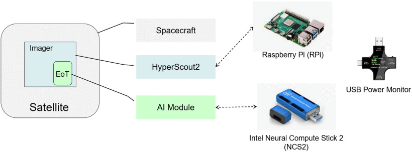
The South Australia team “hardware-hacked” a lab emulator of the hyperspectral-plus-AI payload of the CubeSat, for prelaunch experiments to gauge its effectiveness detecting bushfire smoke from space. [Image: S. Lu et al., IEEE J. Sel. Top. Appl. Earth Obs. Remote Sens. 17, 9629 (2024); CC-BY 4.0]
Next, the scientists indulged in a bit of hardware hacking to create a lab system that would emulate the onboard AI hardware of Kanyini’s HS2 imager. The researchers used the popular Raspberry Pi (RPi) platform and operating system to emulate the basic function of the HS2 imager, and tricked the RPi out with an Intel Neural Compute Stick 2 to simulate the HS2’s AI module.
The researchers then loaded onto this testing platform a previously developed, lightweight neural-network AI model for fire smoke detection called VIB_SD—after first adapting the model to mesh with the specific bandwidth characteristics of Kanyini’s HS2 system. Finally, they trained their lab-based system using the VIIRS-derived training set, and tested the trained model on additional imagery designed to mimic various smoke and smoke-free scenarios the satellite imager might actually encounter.
Slashing downlink volumes
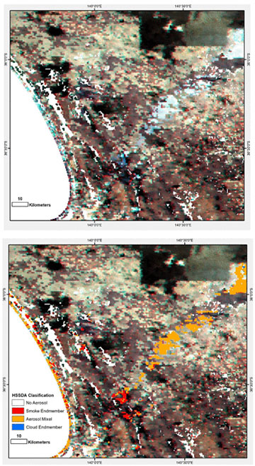
Top: A simulation of hyperspectral data from the HS2 imager, shown as a natural-color RGB image with simulated smoke plumes in bluish-gray. Bottom: The lightweight AI model clearly distinguishes smoky areas (red and orange) from cloud and other signals. [Image: S. Lu et al., IEEE J. Sel. Top. Appl. Earth Obs. Remote Sens. 17, 9629 (2024); CC-BY 4.0]
In their experiments, the team found that the VIB_SD model, operating within the constraints of the planned Kanyini HS2 equipment, demonstrated “a high prediction accuracy and a low false-negative rate” in distinguishing fire smoke from other imaged signals.
What’s more, the tests indicated that, for a scenario in which 10% of the imagery includes fire smoke, the use of onboard processing, rather than sending all the data to the ground for processing, reduced the required data downlink volume to only 16% of its original size, thereby cutting satellite energy consumption by 84%. The researchers write that their system “fills the gap of using a small AI model to detect fire smokes” in the context of a CubeSat, given the limited onboard processing, power and data storage capabilities available on those diminutive spacecraft.
According to a press release accompanying the research, the work showed that such a setup could “detect fires from space 500 times faster than traditional on-ground processing of imagery.” The team believes such early sensing of fire smoke could allow evidence of potential bushfires to be piped into ground-based early-warning systems far faster than would otherwise be the case, contributing to “timely decision-making and intervention in emergencies.”
Postlaunch and beyond
In the wake of this prelaunch work, the research will continue after the Kanyini HS2 instrument is lofted into low Earth orbit later this year. That postlaunch work will include additional calibration and stepwise updates of the emulator AI model with real data from the Kanyini sensor, as well as testing of alternative models. The team hopes to be able to demonstrate the system’s actual use for fire detection in orbit by 2025, and possibly to commercialize the technology for potential deployment across a whole constellation of CubeSats.
“This research shows there are significant benefits of onboard AI compared to traditional on-ground processing” of hyperspectral-imager data, the project’s lead scientist, Stefan Peters, said in the press release. “This will not only prove invaluable in the event of bushfires but also serve as an early-warning system for other natural disasters.”